Advanced computational modeling reveals high-risk earthquake zones across the United States

USGS Map Employs Cutting-Edge Technology to Identify Areas Prone to Damaging Earthquakes
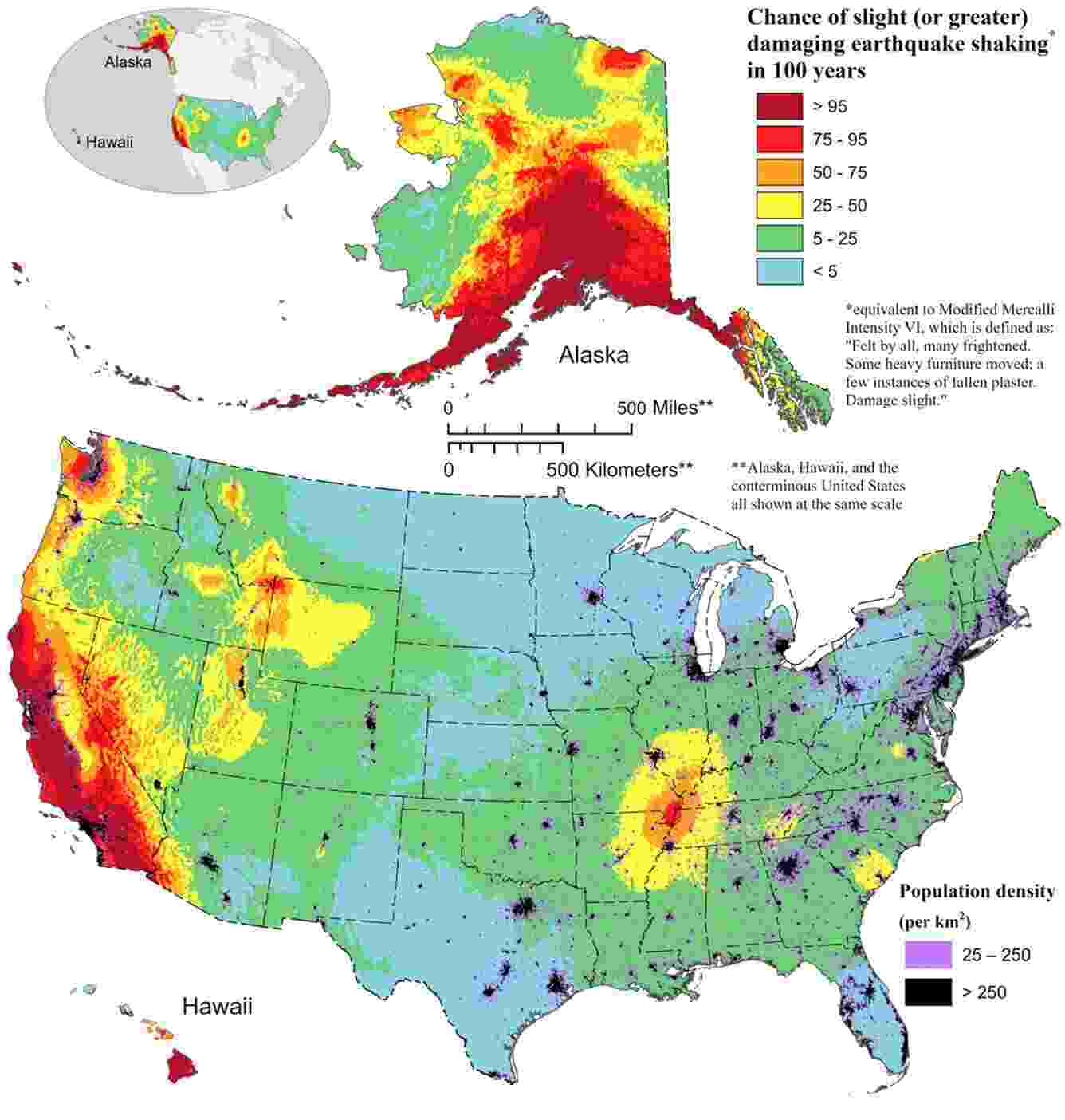
In Golden, Colorado, the United States Geological Survey (USGS) has unveiled an updated National Seismic Hazard Model (NSHM) that employs advanced computational advancements to identify regions most likely to experience damaging earthquakes. This state-of-the-art map, created through multi-year collaborative efforts involving over 50 scientists and engineers, has the potential to revolutionize earthquake research and significantly enhance public safety across the United States.
The NSHM integrates seismic studies, historical geologic data, and cutting-edge data-collection technologies to provide essential insights into earthquake-prone areas, likely earthquake locations, and projected levels of ground shaking. Equipped with computational advancements, this comprehensive model offers the most detailed and accurate assessment of earthquake risks ever conducted in the country.
Mark Petersen, a USGS geophysicist and the lead author of the study, emphasized the significance of this breakthrough, stating, "This new seismic hazard model represents a touchstone achievement for enhancing public safety." The model serves as a critical tool for engineers and policymakers in identifying vulnerable communities and developing strategies to mitigate the impacts of earthquakes.
One notable aspect of the updated NSHM is its coverage of all 50 states simultaneously, making it the first national seismic hazard model to adopt a unified approach. By incorporating data from federal, state, and local partners, this collaborative effort ensures that comprehensive insights are provided for even the most geologically diverse regions of the United States.
The utilization of advanced computational modeling techniques has significantly enhanced the accuracies of the NSHM. Through years of research, scientists have incorporated critical improvements, including the inclusion of more fault data, better characterization of land surfaces, and the application of state-of-the-art modeling capabilities. These advancements have allowed for a more nuanced understanding of earthquake risks, providing architects, engineers, and policymakers with essential insights for designing and constructing structures that can withstand seismic events.
The updated model has produced key findings that shed light on earthquake risks across the country. According to the NSHM, nearly 75% of the United States has the potential to experience damaging earthquakes and intense ground shaking—placing hundreds of millions of people at risk. The model also reveals that 37 states have seen earthquakes exceeding magnitude 5 in the last two centuries, underlining the historical seismic activity experienced throughout the nation.
Moreover, significant variations have been identified in risk zones. The central and northeastern Atlantic Coastal corridor, including cities such as Washington D.C., Philadelphia, New York, and Boston, face a heightened risk of more damaging earthquakes. Similarly, seismically active regions of California and Alaska are also marked as areas with increased potential for intense shaking. The NSHM also recognizes the evolving hazards in Hawaii, taking into account recent volcanic eruptions and seismic unrest on the islands.
However, it is important to note that the NSHM does not predict earthquakes. Rather, it enhances our understanding of fault behavior and past seismic events, helping scientists assess the likelihood and intensity of future earthquakes.
The full findings of this scientific assessment, published in the journal Earthquake Spectra, provide an in-depth understanding of the methodology and results of the NSHM. The map aims to serve as a crucial resource for policymakers, architects, engineers, and other stakeholders involved in public safety and structural design.
As the nation grapples with the constant threat of earthquakes, the USGS's advanced computational modeling presents an invaluable resource. By integrating diverse perspectives from the scientific community and leveraging cutting-edge technology, the NSHM brings us one step closer to safeguarding lives and adapting infrastructure to withstand the tremors that lie ahead.

 How to resolve AdBlock issue?