Seattle Fault traced to ancient continent tear via supercomputer models

A team of geoscientists has conducted cutting-edge research that suggests the Seattle fault zone, a network of shallow faults cutting through Puget Sound's lowlands, originated from an ancient tear in the continent over 50 million years ago. The study, published in Tectonics, uses advanced supercomputer models to shed light on the fault system's earliest history and offers new insights for improving hazard modeling in densely populated regions.
More than four million residents residing in the Seattle area face a significant earthquake threat due to the Seattle fault zone. The research team, led by Megan Anderson, a geophysicist with the Washington Geological Survey, challenges the existing understanding of the fault's origins by proposing a compelling hypothesis derived from magnetic data analysis.
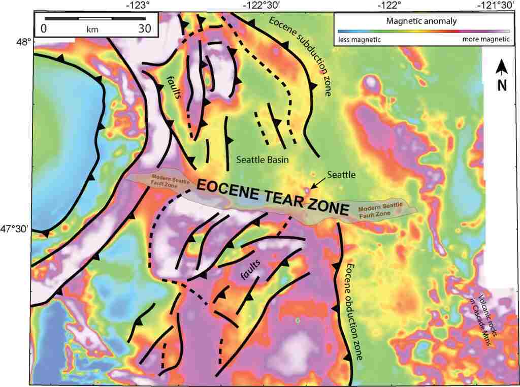
The research team uncovered evidence suggesting that around 55 million years ago, an island chain off the coast of Washington was pulled toward the continent, leading to immense strain on the crust and resulting in a tear in the geologic structure. This ancient tear aligns with the present-day Seattle fault, according to the study.
The researchers combined various datasets, including gravity and magnetic fields, with seismic data to construct a more comprehensive understanding of the region's geological structure. Additionally, rock samples collected from different formations were used to validate the computer models' predictions.
Through the use of supercomputer models, the team identified an intriguing pattern in the magnetic data, revealing that the bedrock alternated between higher and lower magnetic properties, indicating slanted layers of changing rock types. Moreover, the alignment of features on either side of the Seattle fault zone indicated an ancient mountain range, consistent with the team's vertical profiles of the underground rocks, which showed different orientations and a discontinuity in the structures.
Anderson suggests that this tear in the crustal continuum, caused by the intense strain from the island chain's interaction with the continent, created a fragmented and weakened crust, setting the stage for the formation of the modern Seattle fault zone. Understanding this complex geologic history is essential for accurate hazard modeling and earthquake simulations, providing insights into the potential risks faced by the local communities.
The study not only offers a possible explanation for the existence of the Seattle fault zone but also provides valuable details about the underlying bedrock within the Seattle basin. With the basin predominantly filled with looser sedimentary rock, this information enables scientists to develop more accurate models for predicting future ground shaking in the area.
Anderson and her team have not only discovered a buried tectonic story but also laid the groundwork for further investigations into the active faults of western Washington. This multidisciplinary approach, combining diverse datasets and utilizing advanced computational techniques, expands our understanding of the ever-evolving Earth and reinforces the importance of continued scientific exploration.
The study, titled "Deep Structure of Siletzia in the Puget Lowland: Imaging an obducted plateau and accretionary thrust belt with potential fields," was carried out by Megan L. Anderson (corresponding author), Richard J. Blakeley, Ray E. Wells, and Joe D. Dragovich.
POPULAR
- NASA predicts the Sun's corona behavior, revealing its mysteries using advanced computational methods
- Australia on track for unprecedented, decades-long megadroughts: Supercomputer modeling raises concern
- Revolutionizing precision agriculture: The impact of Transformer Deep Learning on water, energy demands

 How to resolve AdBlock issue?