ACADEMIA
Chinese scientists create new global wetland suitability map

Wetlands are among the most productive ecosystems on Earth. Yet with increasing urbanization and agricultural expansion, wetlands around the globe are in danger. Better mapping of wetlands worldwide will help in their protection.
But compiling globe-spanning maps of wetlands is impeded by the dramatic diversity and evolving dynamics of wetlands, and by myriad difficulties in doing field work.
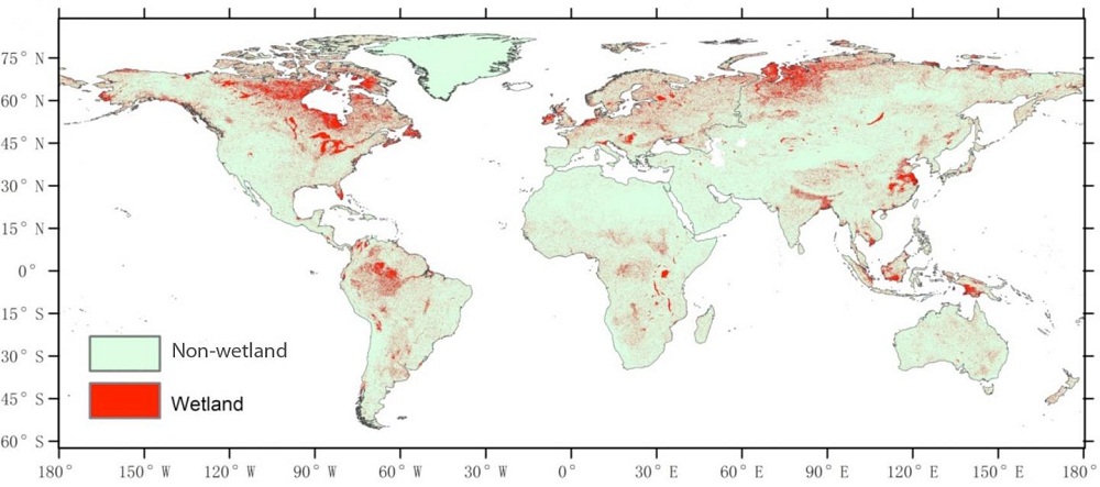
To develop a better model, Gong Peng and other scientists at the State Key Laboratory of Remote Sensing Science, Chinese Academy of Sciences, in Beijing incorporated hydrologic, climatic and topographic data sets into a global wetland suitability map; this new map also matches individual wetland sites with local water table depth.
Professor Gong, who also conducts research at the Center for Earth System Science, at Tsinghua University in Beijing, along with Zhu Peng, a scientist jointly based at the state key lab and at the University of the Chinese Academy of Sciences, outlined their new global wetlands map in a study entitled "Suitability mapping of global wetland areas and validation with remotely sensed data." The new study was published in the Beijing-based journal SCIENCE CHINA Earth Sciences.
Because the evolution-driving mechanisms involving land-surface wetlands vary across different regions due to different climate and landform conditions, a global freshwater ecoregion dataset has been used to construct mapping units that feature model parameters. The new global land surface wetland suitability map produced in Beijing tracks water cycle processes, but is relatively simple and includes fewer datasets. Yet a remote sensing based validation showed the new model has a higher overall accuracy compared with other suitable wetland maps.
Study leaders Zhu Peng and Gong Peng attribute the better performance of their model partially to the adoption of climatic-basin units that each feature unique model parameters and to the incorporation of soil water content datasets from an advanced land surface model.
The modeled results indicate that the total area of global wetlands has reached 3.316×10⁷km2. There is a big gap between this set of results and existing data on worldwide wetland areas. The results are useful not only for scientific purposes, but also to increase understanding of how wetlands have been transformed and how they can be better protected.
In their new study, scientists Gong Peng and Zhu Peng stated: "Our result also proves that exploring and modeling global wetland at high resolution from a water cycling perspective is feasible."
"Since we did not account for the impact of human-induced disturbance to the natural water cycling, our result overestimated the area of global wetland," they added. "In the future we expect that more human impact factors will be represented and more hydrological processes will be included into land surface models to produce more accurate global wetland distribution data."
Their new model, they state, reflects the potential extent of global wetlands and can be used as the foundation for mapping the actual global wetland distribution.
