ASTRONOMY
NASA Support Key to Glacier Mapping Efforts

Thanks in part to support from NASA and the National Science Foundation, scientists have produced the first-ever detailed maps of bedrock beneath glaciers in Greenland and Antarctica. This new data will help researchers better project future changes to glaciers and ice sheets, and ultimately, sea level.
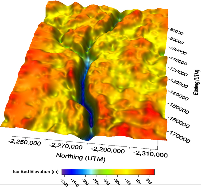
Researchers at the Center for Remote Sensing of Ice Sheets, or CReSIS, at the University of Kansas in Lawrence, Kansas, recently built detailed maps of the terrain beneath Greenland’s Jakobshavn Glacier and Byrd Glacier in Antarctica. The results of this study were published in the September issue of the Journal of Glaciology. CReSIS is a major participant in NASA’s Operation IceBridge, a NASA airborne science mission aimed at studying Arctic and Antarctica land and sea ice.
CReSIS researchers used supercomputer software to process and analyze data collected during field campaigns unrelated to IceBridge that were conducted in cooperation with NASA and NSF in 2008 and 2011 to build maps of the two glaciers. These data were from an ice-penetrating radar instrument known as the Multichannel Coherent Depth Sounder / Imager, or MCoRDS / I, which is similar to the instrument IceBridge has used since 2009. Bed topography data are vital for supercomputer models used to project future changes to ice sheets and their contribution to sea level rise. “Without bed topography you cannot build a decent ice sheet model,” said CReSIS director Prasad Gogineni.
Jakobshavn Glacier is of interest because it is the fastest-moving glacier in the world and drains about 7.5 percent of the Greenland Ice Sheet. Having a map of Jakobshavn’s bed has been a long-time goal of glaciologists. Byrd Glacier is also moving faster than average, but unlike many other glaciers, has been sounded in the past. Researchers mapped a previously unknown trench beneath Byrd Glacier and found that depth measurements from the 1970s were off by as much as a half mile in some places.
Ice-penetrating radar is one method for mapping bedrock topography. The instrument sends down radar waves, which reflect off of the ice surface, layers inside the ice sheet and bedrock back to the instrument, giving researchers a three-dimensional view. Ice-penetrating radar data from IceBridge flights helped build maps of Greenland and Antarctica’s bedrock and were even used to discover a large canyon beneath the ice in northern Greenland.
Imaging rock beneath glaciers like Jakobshavn is important, but more difficult than mapping the ice sheet interior. The relatively warm ice and rough surfaces of outlet glaciers weaken and scatter radar signals, making the bed difficult to detect. To overcome these challenges, CReSIS used a sensitive radar instrument with a large antenna array and used several processing techniques to remove interference and build a view of sub-ice bedrock. “We showed that we have the technology to map beds,” said Gogineni.
The MCoRDS / I instrument can be traced back to an early ice-penetrating radar CReSIS designed and built in the mid-90s in cooperation with NASA and NSF. In the two decades since then CReSIS has refined this instrument and has flown on NASA aircraft and alongside NASA instruments.
Researchers continue to improve instrument hardware and data processing and are looking ahead to mapping more glaciers in the future, which will likely involve small, unmanned aerial vehicles. “Improving ice sheet models means we need even finer resolution,” Gogineni said. “To do this we need lines flown much closer together, which small UAVs would be well suited for.”
For more information on NASA's Operation Ice Bridge, visit:
For more information about the Center for Remote Sensing of Ice Sheets, visit:


