BIOLOGY
Amazonian river winds unraveled by air pollution observations
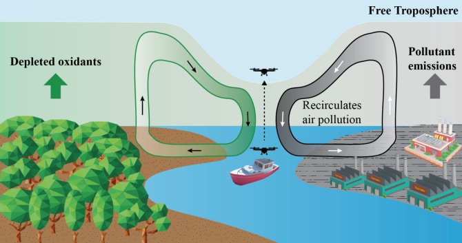
River winds are induced by the daily thermal contrast between the land and the river. During the daytime, warmer temperatures over the land lead to lighter air masses that are lifted. The air masses in turn drive onshore air movement from the river toward the land. Subsequently, the air subsides over the river. The result is a closed local air circulation cell in the vertical plane. At night, the land cools more rapidly, and the air circulation reverses because the river is warmer. Because these driving forces combine with larger and smaller atmospheric flows of trade winds and local topography, the combined river winds remain elusive and difficult to understand, measure, and simulate. A key question then arises: How to obtain accurate observational evidence of these river wind circulations?
Traditional meteorology and pollution measurement platforms are unable to measure how wind, temperature, moisture, and air pollutants change with height above the river. Therefore medium-sized unmanned aerial vehicles (UAV – see photo) were used. They have a potential advance in atmospheric studies due to extreme maneuverability in collecting data at high horizontal and vertical resolutions. Sensor-equipped UAVs were used to collect in situ vertical information of meteorological and chemical data in the lower atmosphere during the daytime over the Rio Negro river in the central Amazon. The impacts of atmospheric recirculation tied to the river winds on the air quality of nearby human populations were considered.
Supercomputer modeling component
To support the interpretation of these observations, this study includes a modeling component to couple field observations of river winds and chemistry with fine-scale modeling analyses using a large eddy simulation (LES). This model is developed at the Meteorology and Air Quality Group of Wageningen University & Research. It is also an important component of the Ruisdael observatory.
The LES simulations examined the effects of river winds on air pollution dispersion. The LES simulation explicitly reproduces the turbulence and atmospheric circulations of the Amazon river winds. The simulations captured the main features of river winds observed by UAV sensing. 
This study shows the need to combine methodologies to measure (drones) and high-detailed modeling (LES). The implication of this study is that air recirculation induced by river winds slows the dispersion of air pollution. It also changes the spatial distribution and chemistry of air pollutants and may increase the risk of human exposure to air pollution in the riparian region. The findings emphasize the need to understand the impacts of river winds on air pollution. It highlights that air pollution management strategies and policies in Amazonia should incorporate the effects of river winds for effective pollution mitigation and control. Further research is being conducted with the NWO project Cloudroots.
