

XSEDE Resources Support Investigations of the Makers of Monster Twisters
Advances in severe-storm research have helped operational meteorologists create better short-term forecasts, with a reduced number of false alarms, increased warning lead times, and more-geographically-specific warnings. But according to Central Michigan University researcher Leigh Orf, who has spent many years using supercomputer modeling and simulation to study twisters, the “holy grail” of tornado forecasting remains a persistent challenge: identifying an atmospheric feature or features that when spotted on National Weather Service radar would serve as a sign that a strong tornado will develop in any given storm or, even better, will form in a storm that has yet to become fully established.
As part of the overarching quest to determine the telltale indicators of an impending monster-size tornado, one of the objectives of Orf’s research team is to capture the entire life cycle of a supercell thunderstorm that produces a strong, long-lived tornado. Supercells are the most powerful, long-lived thunderstorms. They exhibit a rotating updraft, and they are responsible for nature’s mightiest twisters. Adding to the challenge, Orf says, is the fact that only about one in four supercells creates tornadoes, and the vast majority of those tornadoes that do form are not among the vigorous, long-track variety. Orf explains that researchers are so interested in long-lasting tornadoes not only because they do the most damage but also because their existence suggests a balance of sustaining forces not present in storms that produce weaker, short-lived tornadoes. “Identifying this balance of forces would go a long way toward enhancing our understanding of what takes place in tornadic supercells in general, as well as improving our ability to predict tornado formation in any given storm,” he says.
"Most-promosing" Simulations to Date
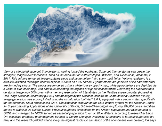
Orf and colleagues—Bob Wilhelmson of the National Center for Supercomputing Applications (NCSA), University of Illinois at Urbana–Champaign; and Matthew Gilmore, associate professor of atmospheric science at the University of North Dakota—recently ran supercell simulations on the Blue Waters supercomputer located at NCSA, and rendered them on the Nautilus system, which is housed at Oak Ridge National Laboratory (ORNL) and managed by the National Institute for Computational Sciences (NICS). Orf says, “Our group has heavily utilized Kraken [also housed at ORNL and managed by NICS] for doing supercell simulations, and without these previous simulations, we would not have been prepared to run on Blue Waters.”
He explains that while this simulation did not produce a strong, long-track tornado, the storm does have features that bear a striking resemblance to those observed in the field. In fact, he says he deems the simulation to be the team’s “most promising” one to date.
Applying Some of the World's Most Powerful Computers
These initial simulations, still being analyzed, are guiding Orf's research team in designing new simulations to be run on Kraken, Nautilus, and Stampede (at the Texas Advanced Computing Center at Austin), all of which are resources of the National Science Foundation’s Extreme Science and Engineering Discovery Environment (XSEDE), the most advanced, powerful and robust collection of integrated advanced digital resources and services in the world.
“The high resolution required for our simulations necessitates the use of some of the world’s most powerful computers,” Orf says. “More modest hardware will enable you to simulate a supercell, but it will not run at high enough resolution to properly capture features associated with the tornado itself, because those features are too small. So, our entire research approach would not have been possible without the use of XSEDE resources.”
Orf’s team is analyzing model results from a simulation that produces two tornadoes over the course of a 15-minute period. “These tornadoes are not as strong or long-lived as the type we are most interested in, but the simulation is one of the very that have been done of tornadic-supercells, and among the highest-resolution ever created,” Orf says.
Seeking a Spectrum of Storms
“With enough simulations, we hope to have a spectrum of storms to investigate, from storms that produce the weakest tornadoes, to those that produce the most devastating, in addition to storms that do not produce tornadoes at all,” he explains. "This data could enable us to tease out the factors in the simulated storms that indicate whether a storm is likely to produce a tornado and, if so, its strength, size, and duration. If such features can be identified on weather radar, this will help operational meteorologists issue better short-term forecasts and more accurate, timely, targeted warnings."
The current work has brought Orf’s team to the point of nearly reaching one of its target objectives: “simulating a supercell that produces a strong, long-track tornado at very high resolution.” “However, we have yet to create a series of simulations with a large spread of outcomes that include no tornadoes, weak tornadoes and strong, long-track tornadoes,” he says. “We hope that the results of our latest simulation will help guide us in designing the necessary series of simulations.”
Related Paper
Orf, L., and E. Kantor, and E. Savory, 2012: Simulation of a downburst-producing thunderstorm using a very high-resolution three-dimensional cloud model. J. of Wind Engineering and Industrial Aerodynamics, 104, 547-557.