GOVERNMENT
A dynamic simulation approach to support emergency decision making on urban public safety

Due to global warming, rapid urbanization and urban sprawl, the occurrence of natural disaster, environmental pollution, social unrest and unexpected urban emergency has been increasing in recent years. This development trend presents urban policy makers the imperative to introduce scientific approaches to support urban emergency management. The concept of resilient city is an effort in this direction which has been increasingly applied and explored in international academia. Yet, in practice in the past, it was common to see decision makers formulating their decisions by referring to personal experience and relevant information collected in urban emergencies. The problem pertaining to this approach is its low level of scientific accuracy and timeliness. To tackle this issue, a Chinese research team has recently proposed a dynamic geo-simulation model. It is an integration of Multi-agent System (MAS) and Geographical Information System (GIS) which enables users to simulate and/or reproduce the complex geographical process of urban public safety emergency response. Through this model, the policy makers are expected to learn the complexity of the process and response quickly with more scientific and reliable emergency decisions and action plans.
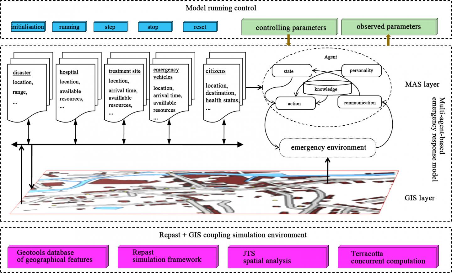
A paper explaining the details of the model has been published (in Chinese) in 2015 3 issue of the journal of Scientia Sinica Terrae. Its title is "Dynamic Geographical Simulation for Urban Public Safety Emergency Response", with Dr. Li Qiang as the first author and Prof. Gu Chaolin as the corresponding author from School of Architecture, Tsinghua University. They successfully applied the theory of Geographical Simulation Systems (GSS) to the domain of urban public safety emergency management and proposed a framework (Figure 1) for modelling large-scale urban public safety emergence response process. The framework can be regarded as a second generation of GSS, featured by an integration of MAS and GIS. The paper not only gives details of the model structure, the properties of the emergency agents and the description of the emergency environment, but also explains the dynamics of the emergency response process, the agents' condition-action rules, and the computational techniques for developing the prototype of the simulation model. This prototype's scientificity, applicability and practicality are testified by a case study of an envisaged emergency response management process triggered in the geographical territory of Beijing.
Urban emergency decision making is a dynamic process involving a range of agents, factors on a multiple scales. First, the factors that entail consideration include both geographical factors (such as distance, event scale and available resources) and psychological factors (such as individual citizen's reaction ability, capability to cope with mental pressure, personal preference regarding evacuation). Second, in the course of events each agent (element) influences and is in turn influenced by all other related agents (elements), which means that the process is co-evolutionary. This multidimensionality and co-evolution feature fundamentally increases the uncertainty and unpredictability of coping with urban emergencies. The research team considered that there are three keys to managing this kind of uncertainty in practice. That is, to tightly integrate the Multi-agent System (MAS) and Geographical Information System (GIS) based on Repast and Geotools, to conduct spatial data analysis through JTS (Java Transaction Service) Topology Suite, and to compute massive real-time dataset by Terracotta clustering technology.
