MOVIES
The Forefront of Severe-weather Research
Darter Supercomputer Supports Most Important Model Forecast Component in Severe-weather Experiment
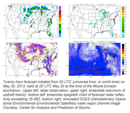
Researchers at the Center for Analysis and Prediction of Storms (CAPS) at the University of Oklahoma ran Storm-scale Ensemble Forecasts (SSEF) April 22 through June 7 on the new Cray XC30 supercomputer known as Darter at the National Institute for Computational Sciences (NICS) in which they captured major hazardous weather events throughout the season. This included the devastating May 20 Moore, Okla., tornado. Investigations such as these aimed at improving hazardous-weather prediction lead to increased severe-storm-warning times for the public. CAPS is the best of the best in the efforts to improve hazardous-weather prediction.
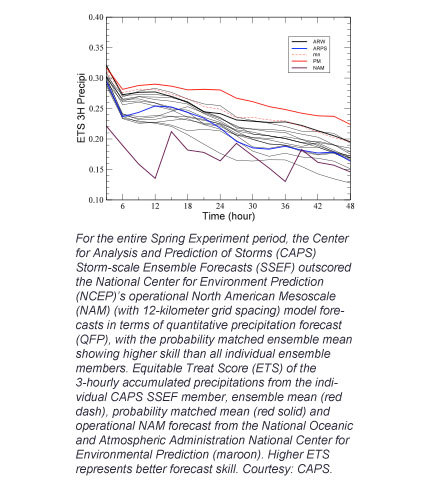
The forecasts were done in support of the National Oceanic and Atmospheric Administration (NOAA) Hazardous Weather Testbed (HWT) 2013 Spring experiment. The NOAA HWT Spring Experiment — which has participants from NOAA Storm Prediction Center (SPC), the National Severe Storm Laboratory (NSSL) and CAPS — is a yearly high-profile experiment that investigates the use of convection-allowing model forecasts as guidance in the prediction of hazardous convective weather. A variety of model output is examined and evaluated daily, and experimental forecasts are created and verified to test the applicability of cutting-edge tools in a simulated forecasting environment. Since CAPS' beginning in 2006, its SSEF remains the most important model forecast component of HWT.
“The dedicated use of the powerful NICS-managed Darter supercomputer made a big contribution to a very successful 2013 Spring Experiment season,” says Fanyou Kong of CAPS. “It allows CAPS to not only produce real-time baseline storm-scale ensemble forecasts for HWT but also to run several combinations of ensemble configurations to find optimization for more accurate prediction of severe-weather events."
The CAPS SSEF runs overlapped with the HWT 2013 Spring Experiment from May 6 through June 7. During the 2013 Spring Experiment, 30 storm-scale ensemble forecasts of 48 hours, at 4-kilometer horizontal grid spacing over the entire continental United States (CONUS) was produced daily starting at 00 UTC (universal time, or world time). Three state-of-the-science numerical weather-prediction (NWP) models were used. They are the Advanced Research version of the Weather Research and Forecast model (WRF-ARW), the Advanced Regional Prediction System (ARPS) and the Navy COAMPS model system.
Each ensemble member forecast has unique initial condition and lateral condition perturbations and model physics options. More than 140 WSR-88D Doppler weather radar and conventional observations over the CONUS were assimilated in real time to each member using the ARPS 3DVAR and Complex Cloud Analysis package. Ensemble forecast products — including probabilistic severe weather guidance, tornadic weather potential and intensity, flash-flood and damaging-wind guidance, were made available to HWT participants 12 to 36 hours in advance.


Related Links
- CAPS — Center for Analysis and Prediction of Storms
- "Long-Term Federal Investments Improve Severe Weather Prediction" (article by the National Science Foundation providing overview of CAPS)
Special thanks to Ming Xue and Fanyou Kong of CAPS for providing the project-highlight content for this article. Editorial support provided by Scott Gibson of NICS.
