PHYSICS
Korean researchers build eco-morphodynamic model to predict the landscape of a river

Climate change is changing the environmental condition of rivers; hence, it is no longer possible to manage modern rivers with methods that have been practiced under past environmental conditions.
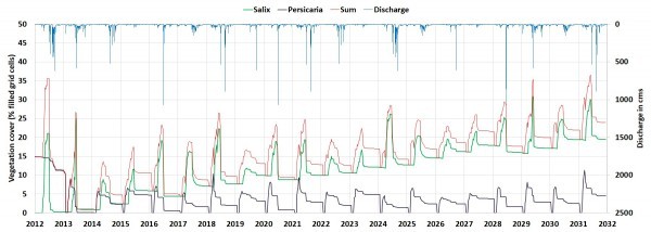
A joint research team, the Korea Institute of Civil Engineering and Building Technology (KICT) and Deltares of the Netherlands, researched prediction of the future changes in river landscapes using an eco-morphodynamic model applied to an actual river. According to the study result, the vegetation cover increases continuously until 2031, and the area covered by willow trees occupies up to 20% of the river area. Using this modeling, efficiency in river management can be achieved by planning management practices.
Eco-morphodynamic model developed by Deltares is a model that combines a vegetation model with Delft3D software, which is widely used in the field of river hydraulics. The Delft3D computes flow velocity, water depth, and elevation of a riverbed. Then the vegetation model simulates the germination, settlement, growth, and mortality of vegetation based on the Delft3D computation. Simultaneously, vegetation properties are converted to flow resistance and fed back into Delft3D.
KICT and Deltares applied the eco-morphodynamic model to Naeseongcheon Stream in Korea which belongs to a temperate monsoon climate region with large seasonal hydrological fluctuations. Most of the Naeseongcheon Stream has characteristics of a natural river. As its riverbed is mainly composed of sand, the movement is due to hydrological fluctuations and consequently, the vegetation dynamics are active.
KICT has been conducting long-term monitoring including LiDAR and hydrological surveys and vegetation map production since 2012, before significant vegetation establishment in Naeseongcheon Stream began. These monitoring data were used to build and verify the eco-morphodynamic modeling. The modeling area is approximately 5 km long curved reach, located in the middle-lower section of the Naeseongcheon Stream. The width is approximately 300 m, and the model's grid was constructed considering the actual vegetation distribution which had occurred narrowly along the shoreline.
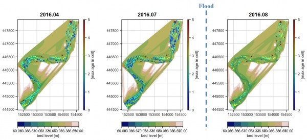
After conducting modeling for the past data(2012-2019 period), the results were compared with the observed data. Compared with the ratio of coverage of tree species in the land cover map made with aerial photos, the area fraction of willow trees in the model result had a similar coverage ratio (In 2014, actual: 2.02%, model: 2.21%). In 2016, the model adequately reproduced the actual situation by simulating the survival and growth of vegetation in the spring and the mortality of vegetation after the flood.
Considering the climate change scenario, the joint research team has performed long-term modeling from 2012 to 2031. The vegetation cover continued to increase until 2031, and the area of trees reached 20% in 2031. 
This eco-morphodynamic model, jointly performed by KICT and Deltares, is a fully coupled model that links the hydrology-vegetation-morphology and can reproduce the actual phenomenon better than other models. It has the advantage of increasing the model's reliability through application and verification in the real river with abundant observed data. With this model, we can predict future changes in a river landscape, ecosystem diversity, and potential flood risks due to vegetation development.
Dr. Lee said, “This eco-morphodynamic model can aid decision-making for implementing appropriate river and vegetation management by simulating the landscape of future rivers according to climate change, though it needs continuous improvement to reflect the complexity of real rivers.”
