Beam me up: From Earth to orbit; Aussie scientists unlock new quantum leap

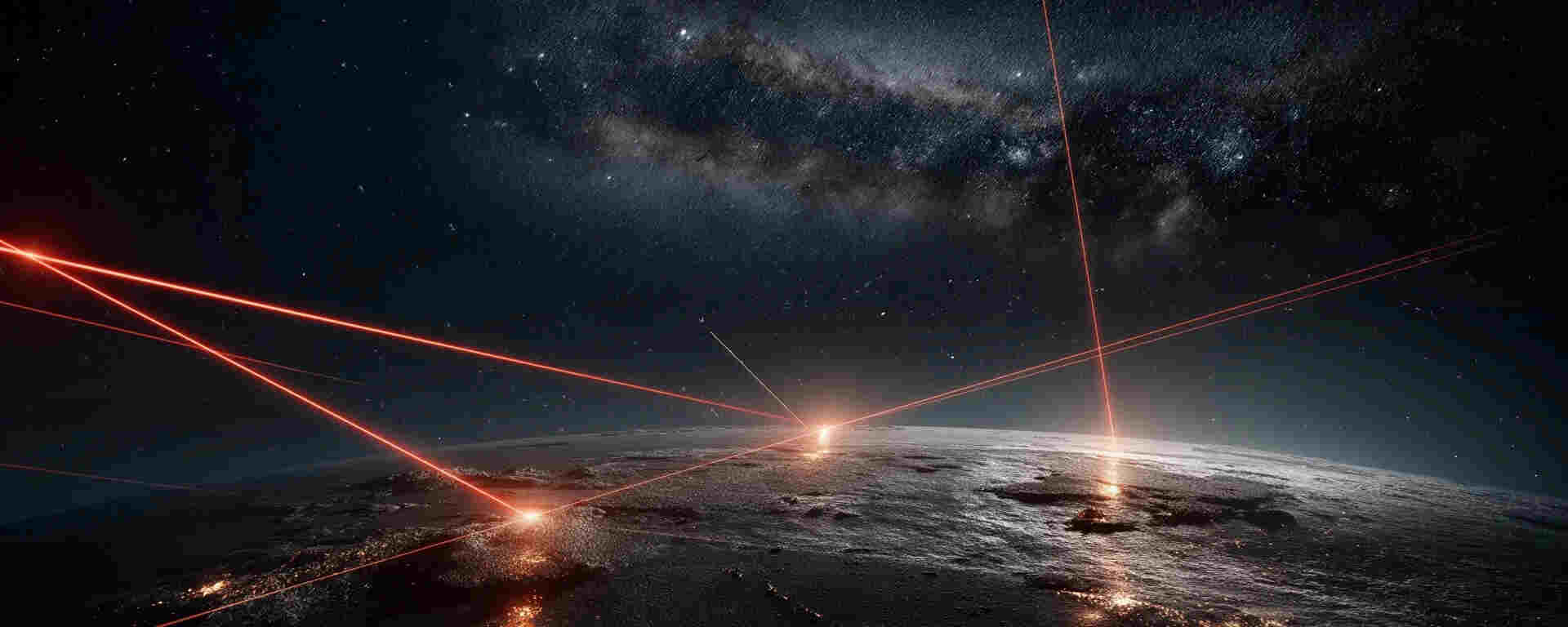
The frontier of quantum communication just flipped; instead of just downlinking from space to Earth, scientists at the University of Technology Sydney (UTS) say we’re now beaming up. A new study reveals it’s feasible to send quantum-entangled particles from Earth up to satellites, a reversal of the usual satellite-to-ground model.
 
Here’s what’s going on and why it matters.

What did they do?

In the study titled “Quantum entanglement distribution via uplink satellite channels,” led by Simon Devitt and Alexander Solntsev, the UTS team ran detailed modeling of the Earth-to-space path of entangled photons. They accounted for real-world complications, including atmospheric scattering, moonlight reflections, ground station optics misalignment, and satellites moving at approximately 20,000 km/h, around 500 km above Earth.
 
Until now, quantum satellites primarily created entangled photon pairs on board and then sent one photon to each of two ground stations (a “downlink” model). The UTS team proposes instead that two ground stations emit entangled photons upward simultaneously to a satellite, where they meet and interfere properly, thus maintaining entanglement.
 
Their findings indicate that this approach is feasible.
 
The uplink path, which had previously been dismissed as too lossy or noisy, can be engineered to function effectively.

Why does this matter?

  • More power on the ground. Ground stations can host stronger photon sources, better maintenance, upgrades satellites are constrained by size/weight/power. Uplink shifts the heavy lifting downward.
  • Higher bandwidth for a quantum internet. The team suggests that for building a true quantum internet (rather than just ultra-secure keys), you need many photons and strong links. Uplink helps enable that.
  • Cost and scalability. Satellites become simpler: instead of needing bulky quantum-hardware, they may only need a compact optical unit to detect interference. That lowers cost and increases scalability.

What about China & global context?

Yes, China has been a leader in quantum satellite communications. Back in 2016, they launched the Micius satellite, the first to demonstrate space-based quantum key distribution. More recently (2025), a Chinese micro-satellite (Jinan-1) achieved a 12,900 km quantum link between China and South Africa.
 
So, UTS isn’t starting from scratch, but they are innovating the direction of the link (uplink vs downlink). It shows the global quantum race is maturing: China has the early wins, but Australia and other players are pushing the next phases.

What’s next & caveats

The research is currently based on modeling, not full-space experiments. While simulating the uplink channel is one thing, real-mission conditions present challenges such as atmospheric turbulence, moving satellites, and alignment drift. UTS suggests near-term experiments using balloons or drones.
 
Furthermore, transitioning from quantum key distribution (QKD), which focuses on secure key sharing, to a full quantum internet, involving quantum computers and sensing, presents numerous engineering hurdles. Uplink technology is just one piece of this complex puzzle.

Bottom line

This development is a significant shift. The idea of firing quantum signals up to space opens new architectures for a quantum internet. It lowers the satellite burden and boosts ground-station capability. If experiments verify the model, the next decade could bring more scalable, global quantum networks than we thought possible.
 
And yes, China’s earlier quantum satellite milestones provide a strong foundation, but this new direction shows the field is evolving beyond “who launched the first quantum satellite” to “how do we build global quantum infrastructure.”

Increased polar ocean turbulence observed in supercomputer simulations of a warming planet

A recent study conducted by the Institute for Basic Science (IBS) and its collaborating institutions presents compelling new evidence indicating that the planet's polar oceans are likely to experience a significant increase in turbulence as climate change progresses. High-performance supercomputing technology was essential to this research.

Simulation at Scale

Researchers at the IBS Center for Climate Physics (ICCP) analyzed ocean currents, ice cover, and horizontal stirring—a process involving winds and currents that stretch and mix water masses, using ultra-high-resolution climate models. These models were executed on the supercomputer Aleph, which is situated at IBS in Daejeon, South Korea.
 
According to IBS, Aleph has a processing capacity of approximately 1.43 petaflops (1.4 quadrillion floating-point operations per second). It is important to note that running these finely-resolved simulations—which track ocean turbulence, sea ice decline, and the mixing of marine ecosystems—demands substantial computational resources, as well as considerable storage and data-handling capabilities. For instance, one ultra-high-resolution simulation generated approximately 5.3 terabytes of data per year of simulated time.
 
The research team conducted simulations using present-day CO₂ levels, doubled CO₂, and quadrupled CO₂ levels, incorporating atmospheric, oceanic, sea ice, and land feedback mechanisms within a fully coupled Earth system model. The simulations revealed a significant increase in "mesoscale horizontal stirring" (MHS) within both the Arctic and Southern Oceans under warming conditions, indicating heightened mixing, eddy activity, currents, and overall turbulence. Regional mechanisms vary; in the Arctic, sea ice loss facilitates more direct wind forcing and eddy generation, while in the Antarctic coastal region, increased freshwater input from melting ice enhances density gradients and strengthens currents such as the Antarctic Slope Current. The ecological consequences are considerable, as intensified mixing impacts nutrient distribution, plankton populations, larval transport of marine life, and even the dispersion of pollutants like microplastics.

Why supercomputing matters

This research underscores the crucial role of supercomputers in advancing climate science. Conventional climate models frequently employed coarse resolutions, with grid scales exceeding 100 kilometers, which limited their ability to accurately represent small-scale eddies and turbulence. In contrast, the simulations conducted by ICCP utilized resolutions of approximately 0.25° for atmospheric modeling and 0.1° for oceanic modeling, corresponding to a scale of roughly 10 kilometers for certain components. Without computational resources such as Aleph, achieving such high levels of resolution and scale would be infeasible. The demands on storage, memory, input/output, and computational throughput are substantial; one study utilized 11,960 cores, generating approximately 1.8 petabytes of output for a particular high-resolution configuration. In summary, supercomputing capabilities unlock critical insights, transitioning models from simplified approximations to detailed, physically accurate simulations of turbulence, eddies, ice-ocean interactions, and marine ecosystems.
 
From a practical perspective, these findings suggest that, in a warming climate, the polar oceans may exhibit behaviors currently underestimated by existing climate models. Increased turbulence will lead to heightened mixing of heat and nutrients, potentially influencing sea surface temperatures, ecosystem structures, and the dispersion of pollutants. From a broader scientific and infrastructural perspective, the study underscores the critical need for advanced computing resources in climate research. As models continue to advance in resolution, coupling, and complexity, such as through the integration of biological systems with physical dynamics, computational demands will continue to escalate. Institutions like IBS are currently preparing for the next generation of computing capabilities.
 
The planet is undergoing a period of increased activity, literally. Thanks to computing power once considered science fiction, scientists are now investigating the complex dynamics of our polar oceans and discovering that the next phase of climate change may manifest not only as gradual warming but also as accelerated turbulence, mixing, and widespread system rearrangements. The supercomputer Aleph has become one of the primary instruments in this evolving process.

RiverMamba: Advancements in flood forecasting

In an era characterized by increasingly unpredictable river fluctuations, a novel tool developed by the LAMARR Institute (for Machine Learning & Artificial Intelligence) in Germany may represent a significant advancement. Their recent introduction of RiverMamba, a deep-learning model, is designed to forecast river discharge and fluvial floods on a global grid.
 
Researchers indicate that RiverMamba can generate forecasts of global river discharge on a 0.05° grid (approximately 5 km resolution) with a lead time of up to seven days.

Key technical features include:

  • The utilization of "Mamba blocks" (bidirectional state-space modules) to model the spatio-temporal routing of rivers and meteorological forcing.
  • Integration of long-term reanalysis data (e.g., ERA5-Land), static river attributes, and meteorological forecasts (ECMWF HRES) to inform predictions.
  • The developers assert that RiverMamba "surpasses both operational AI- and physics-based models" in forecasting accuracy for extreme events.
This is particularly significant for the St. Louis, Missouri, home of this year's SC25 supercomputing show, and beyond. Flood forecasting is a critical undertaking in areas like the Kansas City region, where river basins (e.g., the Missouri and Kansas rivers and their tributaries) can pose unexpected challenges. A model with global coverage and medium-range lead times offers several advantages:
  • Lead-time extension: Up to seven days provides emergency planners with increased preparedness time.
  • Granular spatial resolution: The 0.05° grid enables finer discrimination of catchments.
  • Extreme flood modeling: Enables the analysis of rare, high-impact events, rather than just "typical" flows.
  • Scalability: A global model allows for potential application beyond major rivers to smaller basins, which are often less well-monitored.
For MoveInLab and its KC-first orientation, this means: as climate change nudges more frequent extreme weather, the ability to forecast at finer scales can inform property risk assessment, neighbourhood resilience strategies, and buyer/seller consults about flood hazard.
 
The model, as noted by its developers, has certain limitations. Specifically, observational data may not fully capture human interventions, such as dams and levees, and uncertainties remain in meteorological forecasting. The model's operational readiness across all catchment areas requires further demonstration. For users in the KC area, local calibration may be necessary, as global models often require adaptation to local hydro-geomorphology, urbanization patterns, and data characteristics.

Supercomputing's Advancement in River Flow Modeling

The underlying technology, supercomputing (i.e., large-scale clusters, high-performance computing, GPU farms), has transitioned from modeling galactic structures to modeling granular elements, such as water molecules in rivers. This shift is significant because: Data volume and velocity necessitate processing terabytes of meteorological, land-surface, and hydrological data to predict floods globally at approximately 5 km resolution with a seven-day lead time, an undertaking that posed challenges for traditional models.

Model complexity

The Mamba blocks in RiverMamba embed spatio-temporal routing, which is computationally intensive. Without supercomputing or GPU acceleration, the model would operate too slowly to be practical for real-time forecasting. Operational resilience: Flood-warning centers in regions like the Midwest require models that run quickly, reliably, and frequently to issue timely alerts, which is facilitated by supercomputing infrastructure.

Democratization risk

However, compute-heavy models necessitate resources (energy, hardware, expertise). If only a few institutions can operate them, the benefits may not reach underserved regions, raising equity concerns. In summary, supercomputing is not merely "big machines doing big math" but rather the new infrastructure supporting Earth-system resilience. For flood forecasting, this infrastructure is finally undergoing the necessary upgrades.

RiverMamba represents a significant advancement, characterized by global awareness, fine resolution, and deep-learning capabilities. For the #SC25 and STL audience, this translates to improved tools for understanding and communicating flood risk. However, it is not a "magic bullet." Local adaptation, data limitations, and access to computational resources remain crucial. The era of "smart rivers" is emerging, and the technological underpinnings are being significantly enhanced.